Case-study /
Flooding in the informal settlement of Graveyard Pond, Cape Town


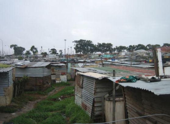
Shacks in the informal settlement of Graveyard Pond located in a stormwater detention pond (photo by Laura Drivdal 30.03.2011)
Introduction
The aim of this report is to provide data and a descriptive understanding of the flooding in one particular settlement that is particularly badly affected: Graveyard Pond in Philippi, Cape Town. By avoiding long theoretical discussions, this report provides empirical insight both for academics as well as for a wider audience.
Graveyard Pond (GP) is one of the approximately 350 informal settlements in Cape Town, as counted in 2008 (CoCTGIS Department count 2011). In the industrial area of Philippi there are, according to the same 2008 count, approximately 55 informal settlements. Research on informal settlements in Cape Town has exposed that these settlements vary greatly, particularly in location, physical form, size, rural-urban linkage, internal poverty and vulnerability.
Methods
This report is based on data collected during the period 14.7.2010 and 31.08.2011. The data gathering process includes over 35 visits to the settlement during this period, carrying out participant observation, interviews with residents, a survey covering most of the settlement, workshops and engaging a „flooding observer‟.
In addition to the survey, most of the relevant information was gathered through visiting theinformal settlement often (including when it was raining) and engaging in conversations withinhabitants. Particularly useful was the participation of the community leaders as „researchassistants‟ / „flooding observers‟. In June 2010 I engaged two flooding observers fromanother settlement and in 2011 (for 6 weeks in June to July) one of the community leaders inGP. The tasks of the flooding observer was to observe, note down comments and takepictures, and these comments and pictures form a large component of this report. Not onlydid this give interesting data and perspectives, but it also increased the confidence andinterest of the assistant to work with the issue.
The report was also validated by the flooding observer and some of the community leaders.
Summary
The Graveyard Pond is a relatively recent informal settlement that seems to have been formed as a result of gradual and unplanned occupation of land. The settlement is located in an area that makes it particularly prone to flooding. However, people have settled there as a last resort, as they could not find other locations. Generally, the main reasons for residents moving there are that it is close to job opportunities, that they were evicted from a the neighboring settlement (Phola Park) due to upgrading (into the RDP settlement Better Life), that they wanted to move away from family to acquire their own space, and that they could not afford rent in backyards. These reasons, in addition to the fact that it is very difficult to find spaces in better-located informal settlements, seem to have outweighed the flooding factor. However, residents do not want to stay there but dream of being relocated.
While hoping to move, they apply basic coping measures to deal with the flooding risk. These coping mechanisms are however insufficient, because, due to the terrain, the water fails to drain for a long time, often settling beneath the floors of the shacks, and the health hazard this can cause is likely to be significant. In its present state, this area, particularly the lowest lying part, appears to be unsuitable for healthy living.
Acknowledgements
Report written by Laura Drivdal, PhD student at the University of Cape Town (UCT), as part of the IDRC / DfID sponsored project, “Flooding in Cape Town under Climate Risk” (FliCCR) at UCT.
The research was carried out in collaboration with the community leaders of Graveyard Pond, who also did a great part of the data collection and monitoring. They have also read and validated this report.
